Mountain Brook Estates
Mountain Brook, Alabama
Excerpted from Warren H. Manning, Landscape Architect and Environmental Planner.
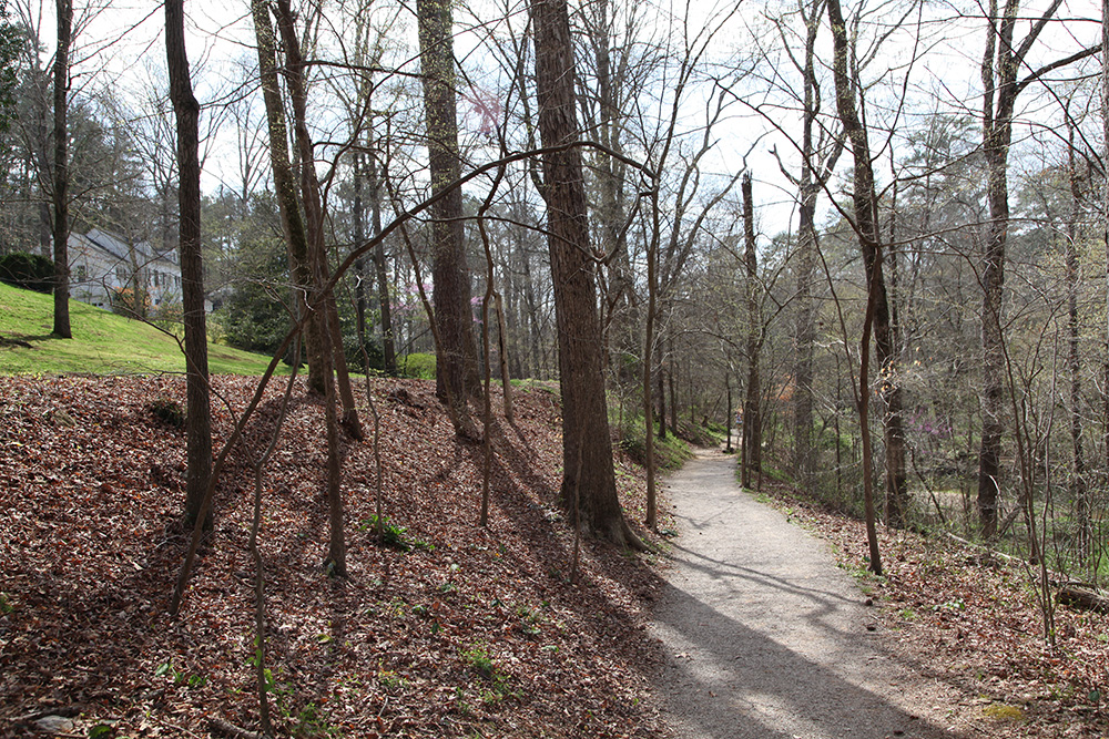
Reverence for place was central in Warren Manning’s approach to developing the residential subdivision of Mountain Brook Estates, south of Birmingham. Identified as “Red Mountain Reservation” in Manning’s 1916 district plan, this geographically isolated stretch of ridge and valley lands extended southwest from Red Mountain to Shades Valley and Shades Mountain. His final plan for Mountain Brook, completed in 1929, was designed to showcase the distinctive features of the natural environment—its streams, cliffs, bluffs, hogback ridges, ancient trees, narrow gaps, ridge ponds, springs, rock formations, and views—and to create a subdivision in harmony with these surroundings, a parklike setting for suburban living. Strategies to protect the natural beauty of the landscape included aligning roads and lots with topographic features, reserving floodplains along creeks for scenic value, recreational use, and stormwater management, and using native plants and materials where possible.
Manning began planning the subdivision in September 1926. Over three years, and through many revisions, he worked out the siting and grading of the roads, open space, and house lots by tramping about in the woods. Among those with him on the planning team were his on-site landscape architect, Carl Lutender, and Birmingham landscape architect and horticulturalist William Kessler. By March 1929, Manning had completed a plan that included roads and bridges, residential lots, open-space reservations and deed restrictions, and other community facilities and amenities—a village center, school, riding academy and bridle trails, and a country club as a focal point for the subdivision.1 Manning associate Egbert Hans, although he apparently never visited the site, drew illustrations and wrote articles, including “The Naturalistic Development of Mountain Brook Estates,” published in American Landscape Architect in January 1930.
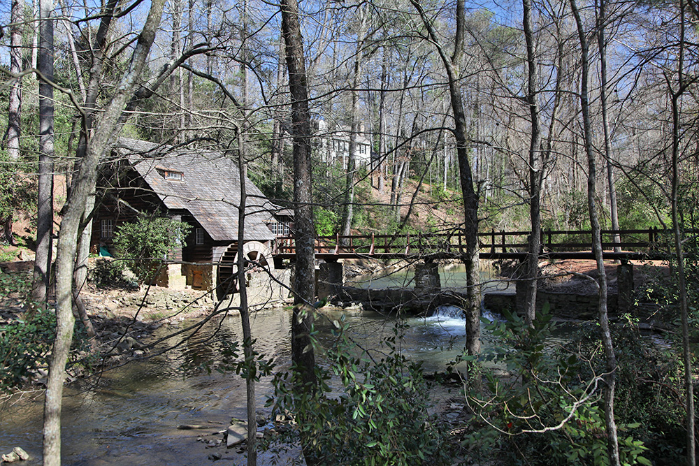
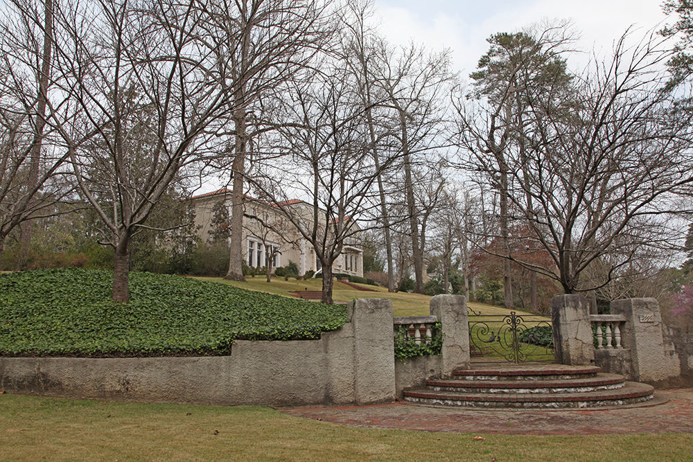
To set the architectural tone for the new residential community, Manning suggested a model country house—a replica of George Washington’s Mount Vernon estate, complete with an “Old Mill,” which was soon opened to the public as a tea room. Manning designed the setting, gardens, and planting plans, while Kessler drew plans for the Old Mill, which followed in the tradition of the Rock Creek Mill in Rock Creek Park, Washington, D.C., and also took cues from Manning’s seventeenth-century family manse near Reading, Massachusetts (see separate entry on the Manning Manse). Architect Aymar Embry designed the clubhouse at the Mountain Brook Club, and renowned golf-course architect Donald Ross laid out the eighteen-hole links.2 Leading local architectural firms drew plans for the subdivision’s Tudor Village, riding academy, and school, as well as for model houses in a variety of architectural styles.3
The road layout followed the contours of the site, favoring curves and keeping straightaways to a minimum, in order to reveal the landscape gradually, in a series of striking views. The banks were planted and graded to slope back from the road edge to ensure visibility. Wooden street signs and stone entrance gates and bridges, both using local materials, continued the naturalistic aesthetic. William Kessler designed the bridges and planting plans for the parkway and entrance gates, and he also sited drives to the house lots.
The development, which comprised about 4,000 acres, was twenty times larger than other developments in the area and on its way to becoming a regional showplace when the stock market crashed in 1929. Soon home sales fell off and construction in Mountain Brook halted. Although the infrastructure, amenities, and several houses had been built by then, and the subdivision was incorporated as the city of Mountain Brook in 1942, construction did not resume until the 1950s.
Although Mountain Brook has grown beyond Mountain Brook Estates, the original subdivision retains a high level of historical integrity, and the National Park Service has included the community in its Historic American Landscapes Survey. The road system Manning designed is still intact. As it approaches the residential areas, Mountain Brook Parkway appears to wind through a sequence of stage sets—from the Tudor Village and Mount Vernon estate to the Old Mill—before reaching the Mountain Brook Club and golf course and ending at Irondale Furnace Park. The route follows a creek, and viewsheds gradually widen along the major floodplain, in which Manning laid out a linear park (since extended and named Jemison Park). On the surrounding ridges and knolls, roads meander throughout the residential community, where the landscape, not the buildings, defines the experience. The original green corridor now enjoys a wider woodland buffer as an indirect result of the 1929 crash. Deed restrictions had been placed on the adjoining estate-sized lots (thirty-five to sixty acres), which extend from the creek up the face of Shades Mountain. Manning envisioned these as home sites for Jemison’s investors in the Mountain Brook venture, but the market collapsed before anything was built. The original deed restrictions, however, still protect the land around Jemison Park from development, creating a green open space at the community’s core.
1. Egbert Hans, “The Naturalistic Development of Mountain Brook Estates,” American Landscape Architect 2, no. 5 (January 1930). The final version of Manning’s General Plan for Mountain Brook, dated March 11, 1929, is held by the Department of Archives and Manuscripts, Birmingham Public Library, in the Robert Jemison Jr. Papers.
2. Planning team: Warren H. Manning to Robert Jemison Jr., August 6, 1928, Jemison Papers. Names of other professionals who worked on the planning for Mountain Brook appear in letters, financial reports, and other records in the Jemison Papers, including daily reports by Carl Lutender. See also the booklet Mountain Brook Country Club and correspondence among the professional consultants during design and construction, in the same collection.
3. The promotional brochure Mountain Brook Estates (Jemison Papers) describes how, in the grand tradition of country estates, the style of each house would fit the topography. Accordingly, the Jemison firm designed a distinctive model home for each section of the development: a Mount Vernon replica for the Mountain Brook section; an all-electric home for Canterbury Road; an English baronial home for Dell Road; and a German stone house for the Southwood Road area. See Julius Linn Jr., Katherine Tipton, and Marjorie White, eds., The Jemison Magazine: Birmingham and Mountain Brook, 1926–1930 (Birmingham, Ala.: Birmingham Historical Society, 2012).
—Marjorie Longenecker White
All photos by Carol Betsch.