NEW ENGLAND TRAILS
TO BE AT THE FARTHER EDGE: Photographs along the New England Trail
Long before the map, there was the trail. It may be the most ancient means of both organizing and experiencing space. In at least some cultures the two ideas are conflated. But for anyone, walking a trail can be a kind of experiential mapping, one not tied to cartographic projections and graphics, but directly to memory, time, and space. If life is defined by movement, life experienced as a path implies direction, and ultimately some transformation or even salvation. The greatest trails have always been pilgrimage routes—journeys of duty and personal growth. The trail, as allegory, maps human experience and lends it purpose and destination.
The most renowned metaphorical trail, at least in English literature, is described by John Bunyan in The Pilgrim’s Progress, a journey from “this world” to the “Celestial City” as revealed to the author in the “similitude of a dream.” The book had a great impact on Protestant theology, not least upon the Puritans of New England, where it must have resonated with real experiences and shared memories of immigration. From the earliest days of the English settlement of Massachusetts Bay and the Connecticut Valley, exodus and personal redemption were linked and identified with the journey to and arrival at a new Zion.
Historians have emphasized a Puritan hatred for the “howling wilderness” of seventeenth-century New England.[1] But the Puritan ethos was never so simple in its attitudes towards the uncultivated world. Milton’s description of Eden as a wilderness “with thicket overgrown, grottoesque and wilde” passionately evokes untrammeled natural beauty. Descriptions of such a “delicious Paradise,” characterized by the profuse and fecund disorder of nature, indicate that wild places did not always signify an evil to be overcome in the Puritan mind. The historian Perry Miller describes the mystical aspects of Puritan theology, which recognized “regeneration” through direct experience of the divine, as an ancestor to the mysticism of New England Transcendentalism, which sought revelation through direct experience of a divine Nature. Jonathan Edwards, an eighteenth-century Calvinist minister who did not allow his religion to prevent him from exalting in the natural world, provided a transformational link in this regional propensity for mystical experience.[2]
New England Transcendentalism is notoriously hard to define, but the meditative activity of walking was perhaps its one sacrament. For Emerson and Thoreau, the appreciation of the natural world was inseparable from this active mode of experience. Romantic sensibility depended not so much on overcoming the wilderness—that had occurred centuries earlier in Europe, after all—but on opportunities to travel for the pleasure of appreciating regional scenery. Seeing places as landscapes was a function of the increased mobility of modern life. Technology transformed perceptions of the world, as improved roads and carriages, canals, steamboats and eventually rail all came in rapid succession. While reactions to these influences ranged from rejection to embrace, modern patterns of living allowed the access and leisure needed to appreciate Nature and to compose landscape scenes, whether on canvas or in the mind.
The itineraries of nineteenth-century tourists soon had their own imagery and literature, which both found large audiences. The phenomenon of tourism began in the Northeast, as cities grew and more metropolitan residents had the means to travel. The historians Laura and Guy Waterman suggest that the Crawford Path (1819) up Mount Washington is the oldest recreational trail in the region still in use. At that time the Crawford family operated an inn at the base of the climb, which served tourists eager to experience the already storied mountains.[3] By mid-century, dozens of “mountain houses” occupied peaks in New England and eastern New York. Both Mount Tom and Mount Holyoke—sites along today’s New England Trail—were early mountain house locations. Unlike Saratoga and other spas, these accommodations were places for taking in the views and cool mountain air, not the waters. Mountain resorts also implied a certain amount of hiking, an activity that generated the earliest clubs devoted to the pursuit, notably in Williamstown, Massachusetts, and Portland, Maine. The Appalachian Mountain Club (AMC) was founded in Boston in 1876 and its members focused their attentions not only on mountaineering, but also on the maintenance of trails and high elevation “huts” in the White Mountains.[4] In 1895, a group of hikers and conservationists established the Connecticut Forest & Park Association (CFPA).
The members of groups such as the AMC and the CFPA shared an enthusiasm for outdoor recreation that extended to advocacy for regional planning and land conservation. By the 1880s, areas of scenic beauty and ecological significance within metropolitan Boston were being destroyed by the expanding city. One prominent member of the AMC, the landscape architect (and inveterate New England hiker) Charles Eliot, enlisted his fellow members to initiate a campaign to create what became, in 1891, the Trustees of Public Reservations, the first land trust dedicated to the preservation of regional scenic and historic landscapes. The next year, the Massachusetts legislature established a Metropolitan Park Commission empowered to acquire and manage scenic reservations in the suburban towns around Boston, with Eliot acting as its landscape architect planning the system.[5]
[peekaboo_content name=”ECblog4″]
Eliot gained his knowledge of the New England landscape early in life through his interests in hiking and map making. He then became a protégé of Frederick Law Olmsted, who in the 1880s was completing his most significant urban park system, the “Emerald Necklace” of Boston and Brookline. When Eliot in turn planned his regional park system in the 1890s, he included connecting “parkways,” an essential part of the landscape-based approach to urban planning that he had learned from his mentor. These corridors of parkland could include carriage drives, pedestrian ways, and sometimes commuter rail lines. Parkways could serve multiple purposes, including water quality improvement in places where they followed the course of a river. They were early examples of what would later be called “greenway” planning, or regional planning based on the connection of significant natural, cultural, and recreational resources through the establishment of a landscape corridor. For Eliot, they were perhaps above all walkable corridors—trails—connecting a system of representative types of regional landscapes around Boston.
Much of the potential of park and parkway urbanism was undermined in the twentieth century, however, as landscape corridors became arterial highways to serve the automobiles that rapidly overwhelmed American cities. The automobile also made scenic places outside metropolitan areas accessible to tourists in much greater numbers than ever before. Across the country, and particularly in national parks and other scenic areas, automotive tourists arrived in large numbers during the decade following World War I. The national park system was redeveloped to a significant extent to accommodate the trend, and numerous state park systems were established for much the same purpose. In both cases, park agencies hoped to encourage the enjoyment of scenic and historic places, and also to prevent popular destinations from being destroyed. New hiking trails, as well as roads, were part of park plans. But wherever previously remote places were being overrun by tourists in cars, or wherever new park roads were being built, at least a few individuals objected and suggested alternatives to automobile-based outdoor recreation.
The most significant of these alternatives took shape in New England. It involved a new, regional approach to recreational land use and cultural landscape conservation that had at its core, not an automotive parkway, but a long-distance hiking trail. The Appalachian Trail, as described by regional planner Benton MacKaye in 1921, called for connecting trails that had already been created by hiking clubs in New England (most notably the Long Trail in Vermont completed in 1910), and extending a continuous trail corridor along the Appalachian Mountains all the way to North Carolina.[6] More than just a trail, the project was a “new approach to the problem of living,” anticipating and addressing changes in agriculture, forest management, and rural life that were already underway up and down the Appalachian region. MacKaye had spent much of his childhood in Shirley Center, Massachusetts, hiking the surrounding hills and making his own maps. He envisioned the Appalachian Trail as just one part of a larger plan to establish rural communities (perhaps not so unlike the New England village of his youth) based not only on opportunities for outdoor recreation, but also on agricultural and forestry occupations. “Coming as visitors,” MacKaye predicted, some “would be loathe to return. They would be desirous of settling down in the country—to work in the open as well as play.”
MacKaye’s vision of living on the land in communities connected to one another, and to other population centers, through a network of hiking trails would not be realized. But volunteers quickly made at least portions of the Appalachian Trail a reality. As was the case since the nineteenth century, members of regional hiking clubs provided the necessary labor and enthusiasm. The AMC and the Green Mountain Club were soon joined by the Palisades Interstate Trail Conference, the Potomac Appalachian Trail Club, and numerous others organizations that built and maintained the trail, which was declared to be complete in 1937.
In the decades following World War II, Americans embraced outdoor recreation in unprecedented numbers. Parks and other favorite recreational destinations were often overwhelmed, and in 1958 Congress responded by creating the Outdoor Recreation Resources Review Committee (ORRRC).[7] The ORRRC noted that one of the most widespread forms of recreation in the U.S. was walking, and that better provision for this simple but pervasive form of leisure activity should be made nationally. By the time the ORRRC report was released in 1962, Stewart Udall had been made Secretary of the Interior. Udall was a passionate advocate for the creation of a national system of trails, based on the precedent and success of the Appalachian Trail. Legislation to make the system a reality became an important component of his “New Conservation” agenda.[8]
Congress passed the National Trails System Act in 1968, defining “national recreation trails” and “national scenic trails” as types of trails to be included in the system. “National historic trails” were added ten years later. Each type has its own purpose and represents distinct interests and experiences. National recreation trails are often shorter, and accessible to major cities. National historic trails capture routes of great significance, such as the Oregon Trail and the Trail of Tears. The 1968 act described national scenic trails as a combination of these potentials, with the added distinction of outstanding beauty: “Trails so located as to provide for maximum outdoor recreation potential and for the conservation and enjoyment of the nationally significant scenic, historic, natural, or cultural qualities of the areas through which such trails may pass.”[9] Included in the legislation, the Appalachian Trail and its western counterpart, the Pacific Crest Trail, were designated as the country’s first two national scenic trails.
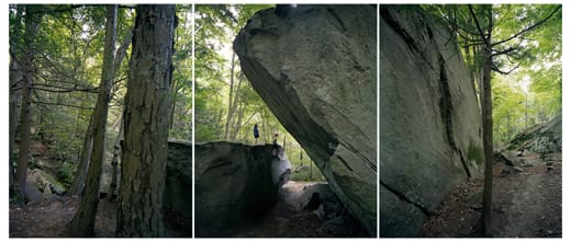
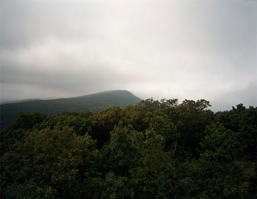
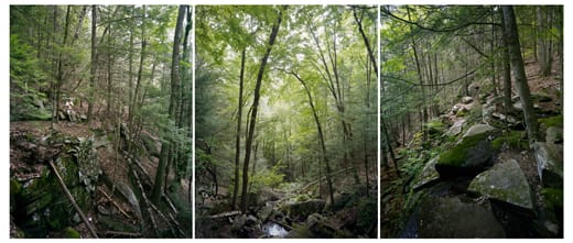
The New England Trail, so beautifully represented in Barbara Bosworth’s photographs, is the most recent addition to the system of national scenic trails, which now includes thousands of miles of long-distance trails. The New England Trail has its share of peaks, waterfalls, and deep forests, and it also passes by some of the oldest settlements in New England, starting in Guilford, Connecticut (1639) and continuing north to Hadley, Massachusetts (1659). The valuable farmland along the Connecticut River and its tributaries drew Puritans to this cultural landscape during the earliest period of English settlement. The New England Trail allows visitors to experience places shaped and occupied by subsequent generations of New Englanders, some of whom were central to the history of landscape appreciation and conservation in the United States. Jonathan Edwards preached in Northampton, Massachusetts, a town visible from Mount Tom, along the trail. Thomas Cole painted the view from Mount Holyoke, where an early mountain house, the 1851 Summit House, still stands. Emily Dickinson wrote her poetry in nearby Amherst, visible below. Olmsted was born and grew up in Hartford, Connecticut. MacKaye’s Shirley Center is some 50 miles east of the New England Trail, but the philosophy and longevity of his vision are affirmed the nation’s newest national scenic trail, and by the hikers, volunteers, other individuals actively engaged in the rural landscapes that the trail passes through.
The New England Trail reveals a specific kind of storied, New England landscape beauty that has been the inspiration of painting and poetry for 200 years. Bosworth’s photographs capture and continue this tradition. The history and spirit of New England trail-making and trail-walking deserve their own national recognition, and the New England Trail is perhaps a place, and an experience, for this. The entire hiking and long-distance trail movement had its origins here. Bosworth’s photographs vividly evoke an experiential and temporal beauty that reminds us that such landscape interpretation is something that must be done in the landscape, on the trail, engaged with the place.
[/peekaboo_content]
[peekaboo name=”ECblog4″ onshow=”Read less…” onhide=”Read more….”]
[1] Benton MacKaye, “An Appalachian Trail: A Project in Regional Planning,” The Journal of the American Institute of Architects (October 1921).
[2] Edwin M. Fitch and John F. Shanklin, The Bureau of Outdoor Recreation (New York: Praeger Publishers, 1970), 60-88.
[3] Steve Elkinton, et al., The National Trails System: A Grand Experiment (Washington, DC: Department of the Interior, 2008), 4-12.
[4] See http://www.nps.gov/nts/legislation.html for the full text of the act.
[5] Laura and Guy Waterman, Forest and Crag (Boston: Appalachian Mountain Club, 1989), 39-43.
[6] Waterman, Forest and Crag, 57-68, 183-92.
[7] Charles W. Eliot, Charles Eliot, Landscape Architect [1902] (Amherst: University of Massachusetts Press in association with the Library of American Landscape History, 1999), 316-35.
[8] See for example Roderick Frazier Nash, quoting Michael Wigglesworth and others, in Wilderness and the American Mind [1967] (Fourth edition, New Haven: Yale University Press, 2001), 34-43.
[9] Perry Miller, “From Edwards to Emerson” [1940], in Errand Into the Wilderness (Cambridge: Harvard University Press, 1956), 184-203.